Editions in foreign languages
Editions in foreign languages

12-th volume of Histories of England … (Histoire d’Angleterre) in French was printed in 1738 in Hague (Holland).
Paul Rapin de Thoiras (1661-1723) was a Frenchman responsible for publishing ten elaborate volumes on the History of England Histoire D Angleterre published in a little fortress-town Vessel (Prussian district of Düsseldorf) between 1724-27. The first volume was issued in 1724 right after death of the historian, and the last – in 1735. It is possible to make an assumption, that the 12-th volume of Histories that is in our possession, which contains the description of the last decade of the Queen Anna’s reign, is the second edition of the author, as it is dated by 1738. The work had been continued by a Parisian publisher David Duran, and published by the Dutch publishers – Pierre de Hondo and Van Duran.
Interesting facts!
Among readers of the academic library at the Petersburg Academy of sciences there was also the princess Anna (1718-1746), the future Queen of all Russian empire. In the list of the French books which were registered for it during 1734-1735, there were also ten volumes of Histories of England.
In the Moscow book-store the work by Paul Rapin de Thoiras had gone on sale on April, 18th, 1749, and had been purchased by nobody till 1759 because of its extremely high price. Cost of the edition with the appendix made 56 rubles and 50 kopecks, while a pound of white bread cost only 19 kopecks at that time. There were too many people who wished to get the book but only in the case of cheaper.
Later the Histories of England had been translated into Russian by court adviser Stephan Reshetov. However only 6 books were printed at the imperial Academy of sciences and after death of the translator the publication was terminated. His widow sold the rests of the work to the Academy of sciences in 1784.
These are the Mémoires of Anne-Louise d'Orléans, duchesse de Montpensier (Mlle de Montpensier, usually called "la grande Mademoiselle"), one of the more endearing and beloved members of the French royal family. We are entering the memoires from the 18th century edition of Adolphe Chéreul. The books, alas, were printed in London in 1746 on the muck that passed for paper in that otherwise illustrious century and they are crumbling to dust even as I type. The text and most of the notes are in French.
The notes by and large are biographical, so that if you know who someone is (or don't care), you won't want to look at the note.

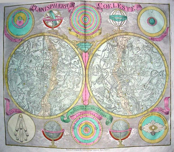
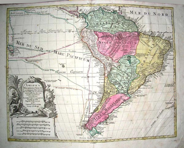
One of the most popular book within our readers if the World Map by Tobias Lotter who was a German publisher and engraver who married the daughter of the elder Matthaus Seutter. He engraved many of Seutter's maps and eventually succeeded to the business in 1756, becoming one of the better-known cartographers in the eighteenth-century German School.
After his death the business was carried on by his son, M. A Lotter.
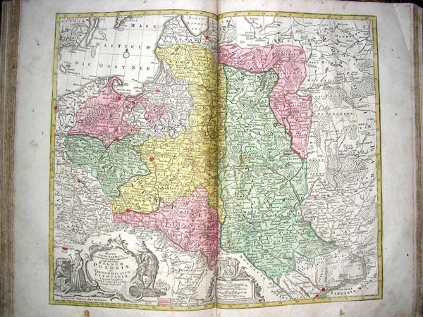
Lotter’s sons Mateus Albrecht Lotter (Matthias Albrecht Lotter) (1741-1810) and George Fridrih Lotter (Georg Friderich Lotter) (1744-1801) also practiced in map engraving and publishing. They signed some of printed atlas boards and maps. So, a map of Portugal (Regna Portugalliae et Algarbiae) was engraved in 1762 by George Lotter, a map of Belgium (Belgica Foederata) is executed by Matthias Lotter. Comparing the originals of Lotters’ maps on other websites we can state that the first engraving of the map of Poland (Regnum Poloniae et Magnum Ducatum Lithuaniae…) was made in 1772 by Lotter and a sample of our item was made twenty years later by his successors as the borders of Rich Pocpolita for 1772 (the first part), and for 1793 (the second part) were specified.
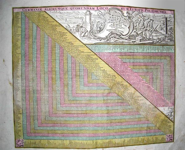
The map collection consists of 50 maps, cope engravings, and hand colored maps.
The atlas has not only scientific, but also art value. Ancient maps really represent a work of art with its exact engraving. Thanks to its numerous illustrations we have an opportunity to visit many parts of the world, but Australia, parts of Northern America and a part of Siberia as they are simply omitted there. At the end of XVIII century these parts had not been investigated enough yet.
But it is possible to find Ukraine on a map of Poland. At that time the right-bank part of Ukraine belonged to Poland, and the left-bank to Moskovia. But the main thing is that the town of Kherson has been already specified on this map.
How many prints of these maps were made in general is still unknown. Most likely, that the circulation was not very significant as a map manufacture was quite hard work and long enough. And we believe that the atlas that we posses is one of a few duplicated copies, but the historical and scientific value of it is still very important.
|
|
|
|
|
|
Map of the Universe |
Map of Poland |
Map of the South America [1770] |
Table of European distances [1750] |
Reference:
- French book in Russia in XVIII cent. Historical sketches /BAN USSR. – Leningrad «Science», 1986. p.58, 70, 78-80, 160.
- http://www.maphist.com/
- http://www.rusbibliophile.ru
- http://www.artantique.ru